The Indian military is set to get access to the giant satellite network of the United States allowing it to target enemy positions with more precision. India and US militaries have decided to ink a deal to share real-time geospatial intelligence, information on maps and satellite images for defence.

India will sign a contract with the US for Basic Exchange and Cooperation Agreement for Geo-Spatial Cooperation (BECA) during 2+2 ministerial dialogue on Tuesday.
The agreement pertains to exchange of Geospatial Intelligence information for use by the governments for defence and other purposes.
Under the agreement, the US would exchange technical and procedural information about standardisation of methods, specifications and formats for the collection, processing and production of Geo intelligence information with India.
It shall also include the tools and models to process GPS data and transform Latitude, Longitude and Height coordinates across various reference frames and others. It will also allow India to use global geospatial maps of the US for accuracy of stand-off weapons like cruise and ballistic missiles.
The decision was taken during the India-US talks on military issues in New Delhi on Monday.
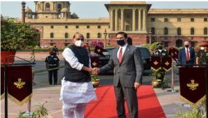
Indian Defence Minister Rajnath Singh and his US counterpart Mark T. Esper held talks on various defence and security issues ahead of 2+2 dialogue between both the countries.
After the bilateral meeting at the South Block, Rajnath Singh said that the talks “were fruitful, aimed at further deepening defence cooperation in a wide range of areas”.
India’s Defence Ministry also issued a statement about the meeting.